Temperature extremes can occur during the summer or winter period, and disrupt the electricity demand and production. Climate forecasts for up to 4 weeks ahead, known as sub-seasonal forecasts, can provide an insight into the conditions for the coming weeks and help predict extreme weather events, such as a prolonged period (several days) of abnormally hot temperatures or heatwave in summer, or unusually warm or cold temperatures in winter (warm and cold spells).
Within the framework of the S2S4E project, an outlook of the sub-seasonal forecasts will be issued weekly for 1-4 weeks ahead, which can be used to anticipate these temperature extremes. The forecasts will be made available every Friday on this page.
A detailed explanation of how these forecasts can be interpreted, and a use case of how sub-seasonal forecasts predicted the heatwaves in summer 2019 are provided in the Summer Extremes factsheet. This factsheet can serve as a basis for intrepreting outlooks issued for both winter and summer extremes.
Sub-seasonal and seasonal forecasts for other regions, variables and forecast windows are available in the S2S4E Decision Support Tool.
Winter Extremes
Outlook - 18 December 2020
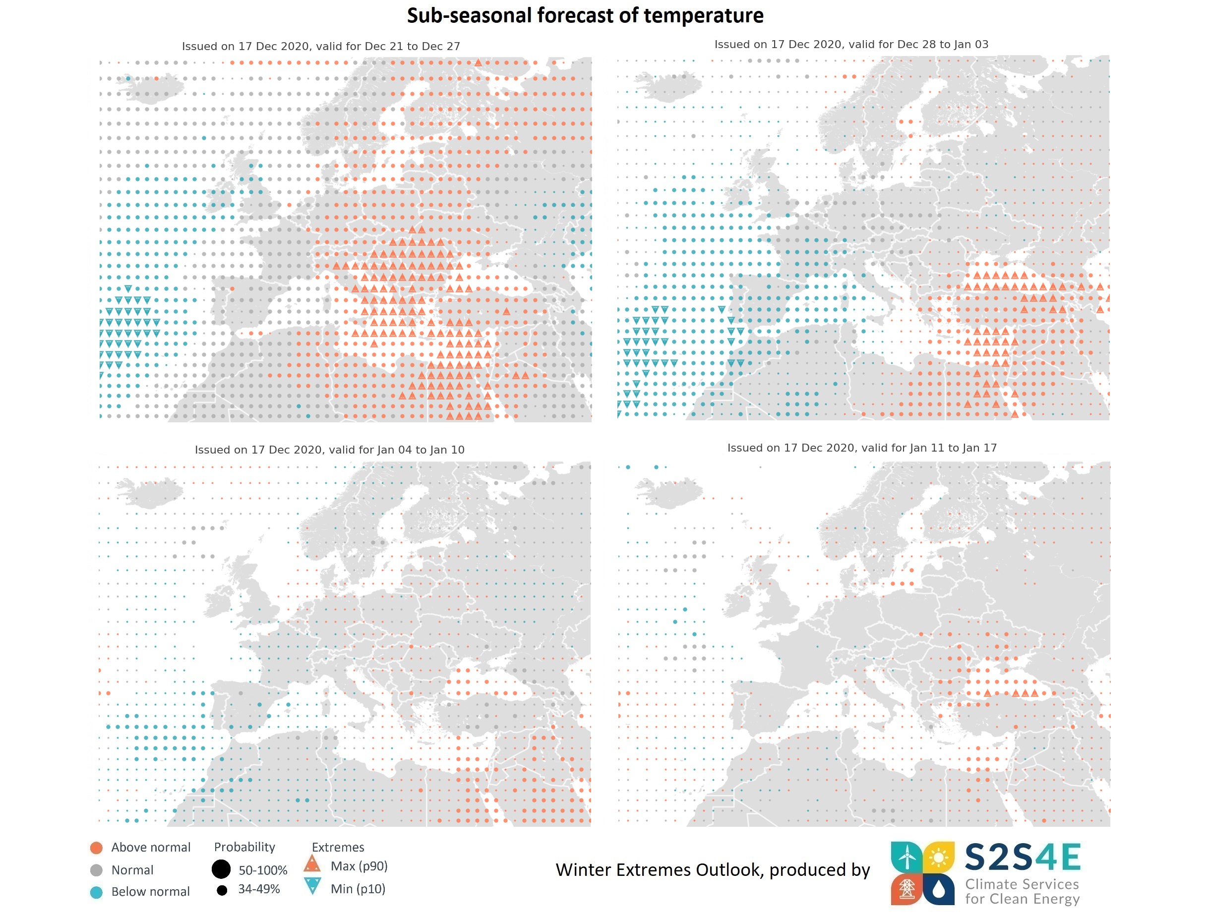
Sub-seasonal forecasts issued on the 17th of December indicate that unusually warm temperatures for the season are expected in parts of central and eastern Europe in the week 21-27 December, with a risk of extremes in Italy, the Balkans, Greece, Cyprus and eastern Mediterranean Sea. In addition, warmer than normal temperatures will be seen in Scandinavia. In the week 28 December to 3 January, above normal temperatures will persist in eastern Mediterranean, while western Europe will see unusually low temperatures for the season, particularly in France, Spain and Portugal. Forecasts issued 3 and 4 weeks ahead show no strong signals of temperature extremes, although above normal temperatures might be seen in parts of southeastern Europe.
Outlook - 4 December 2020
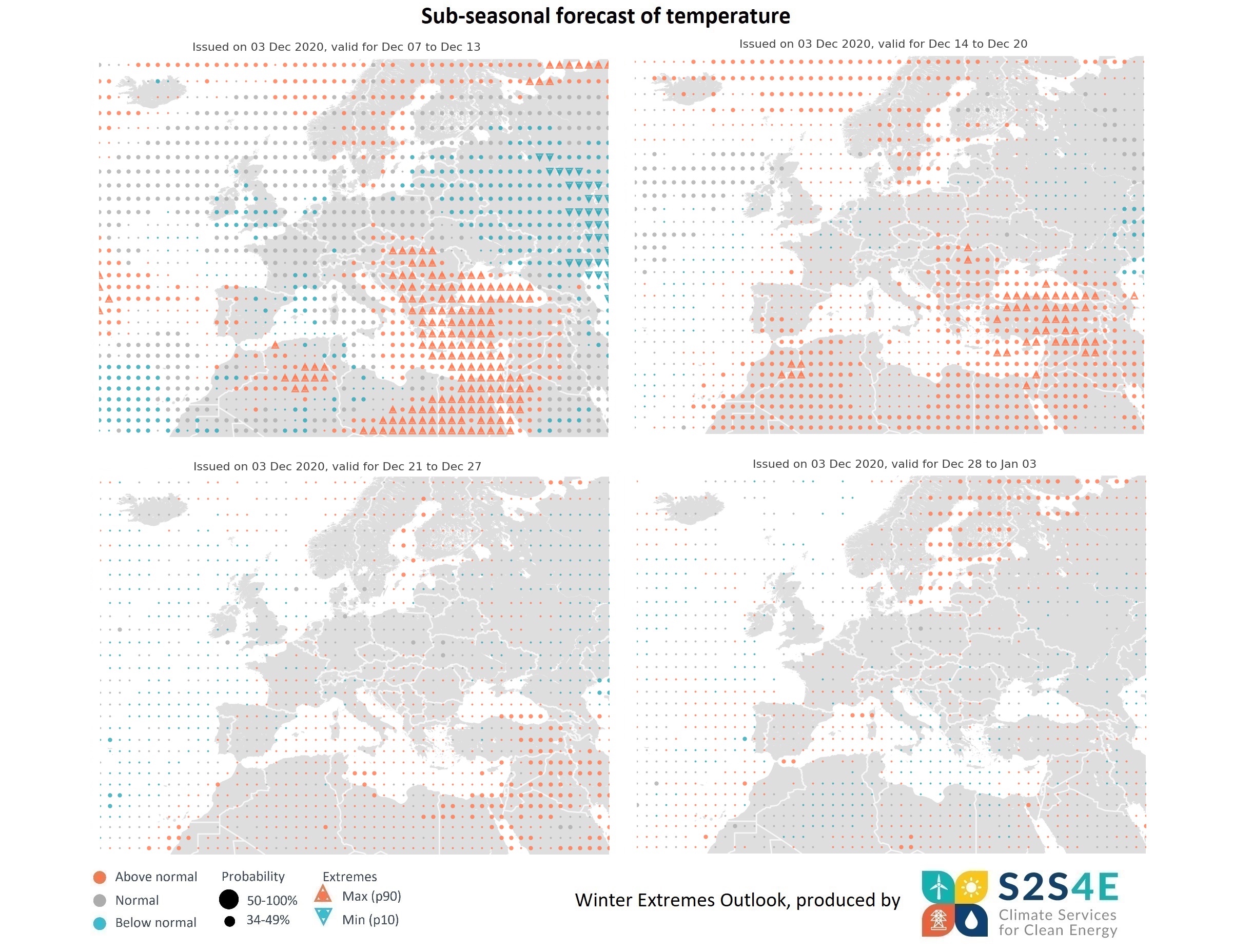
Sub-seasonal forecasts issued on the 3rd of December predict unusually high temperatures in the Balkans, Turkey, Greece, Cyprus and eastern Mediterranean Sea for the week 7-13 December, with a risk of high extremes. By contrast, the UK and parts of eastern Europe will see below normal temperatures. In the week 14-20 December, higher than normal temperatures will persist in southeastern Europe, as well as in Scandinavia and the south of Spain. Forecasts issued 3 and 4 weeks ahead show no strong signals of temperature extremes, although above normal temperatures are predicted in parts of Scandinavia.
Outlook - 27 November 2020
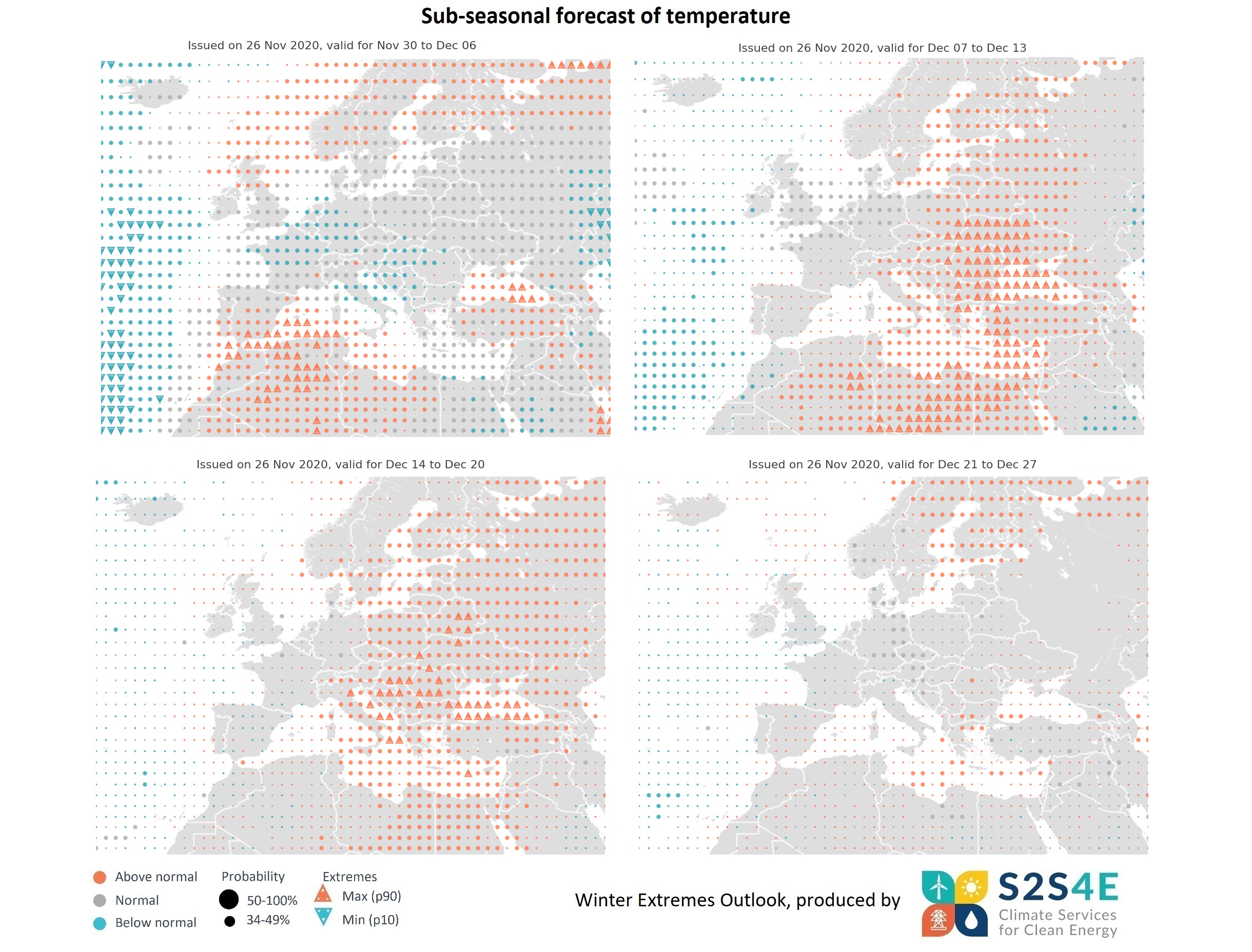
Sub-seasonal forecasts issued on the 26th of November show that warmer temperatures than the normal conditions for the season will be seen in the Black Sea region, western Mediterranean Sea and the south of Spain in the week 30 November to 6 December, with a risk of extremes. In addition, above normal temperatures are expected in Scandinavia that same week. In the week 7-13 December, unusually high temperatures are expected in eastern Europe, with a risk of extremes in Ukraine, the Balkans and eastern Mediterranean. A risk of extremes will persist in parts of eastern and central Europe, and in the Adriatic Sea in 14-20 December. Forecasts issued 4 weeks ahead (21-27 Dec) show above normal temperatures persisting in Scandinavia.
Outlook - 20 November 2020
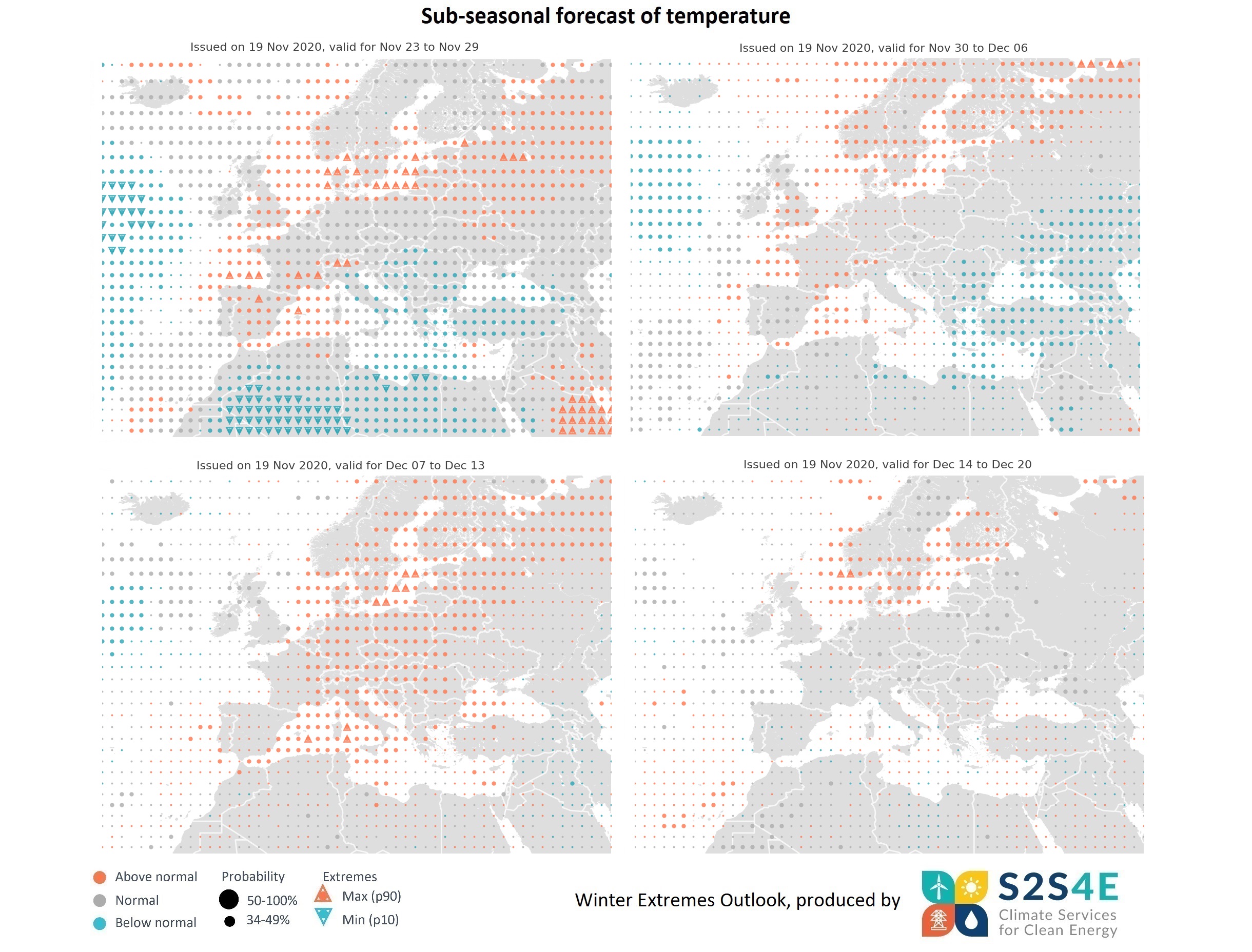
Sub-seasonal forecasts issued on the 19th of November show that warmer temperatures than the normal conditions for the season are expected in western and northern Europe in the week 23-29 November, with a risk of extremes in certain areas. By contrast, below normal temperatures are predicted in the Balkans and eastern Mediterranean in the same week. Forecasts for week 30 November to 6 December predict a similar pattern of warmer/cooler temperatures, although no risk of extremes is expected. In the week 7-13 December, forecasts show mild temperatures above the normal conditions for the time of year throughout central and northern Europe, with a risk of high extremes in the Baltic and Tyrrhenian Sea regions. Forecasts issued 4 weeks ahead (14-20 December) predict that above normal temperatures will persist in southern Scandinavia and the Baltic Sea area.
Outlook - 13 November 2020
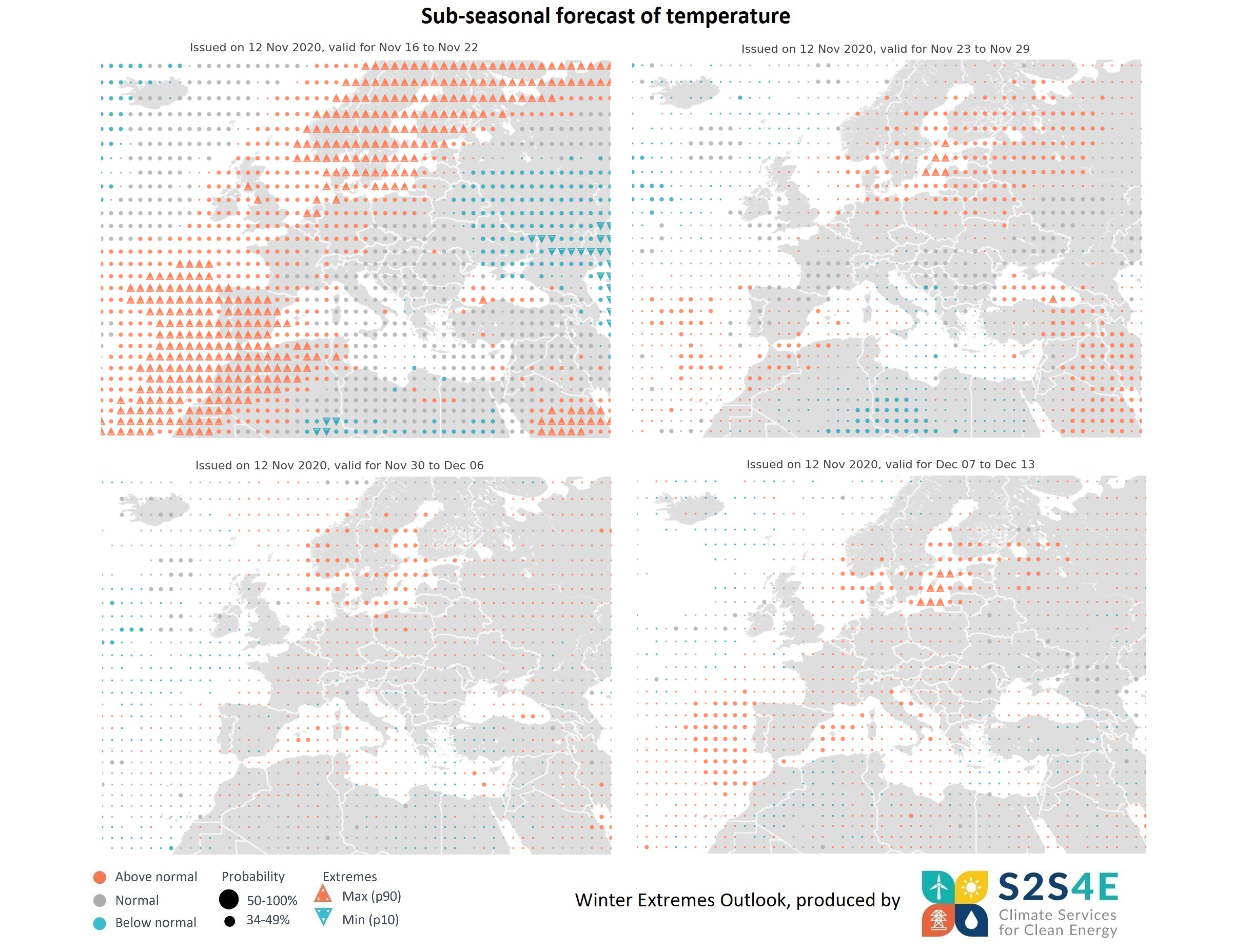
Sub-seasonal forecasts issued on the 12th of November for the week 16-22 November predict that the temperature is expected to be warmer than normal for the season throughout most of eastern and northern Europe, with a risk of high extremes in Scandinavia, the Baltic Sea region, the Netherlands, parts of the UK, Spain, Portugal, and the Canary Islands. In central Europe, normal temperatures for the season are expected for that week. Forecasts for 2 weeks ahead (23-29 November) show that temperatures above normal will persist in the Baltic Sea and surrounding regions. Forecasts for 3 and 4 weeks ahead predict that the warmer temperatures will continue in December in the Baltic Sea and southern Scandinavia region, with a risk of high extremes in the week 7-13 December.
Outlook - 6 November 2020
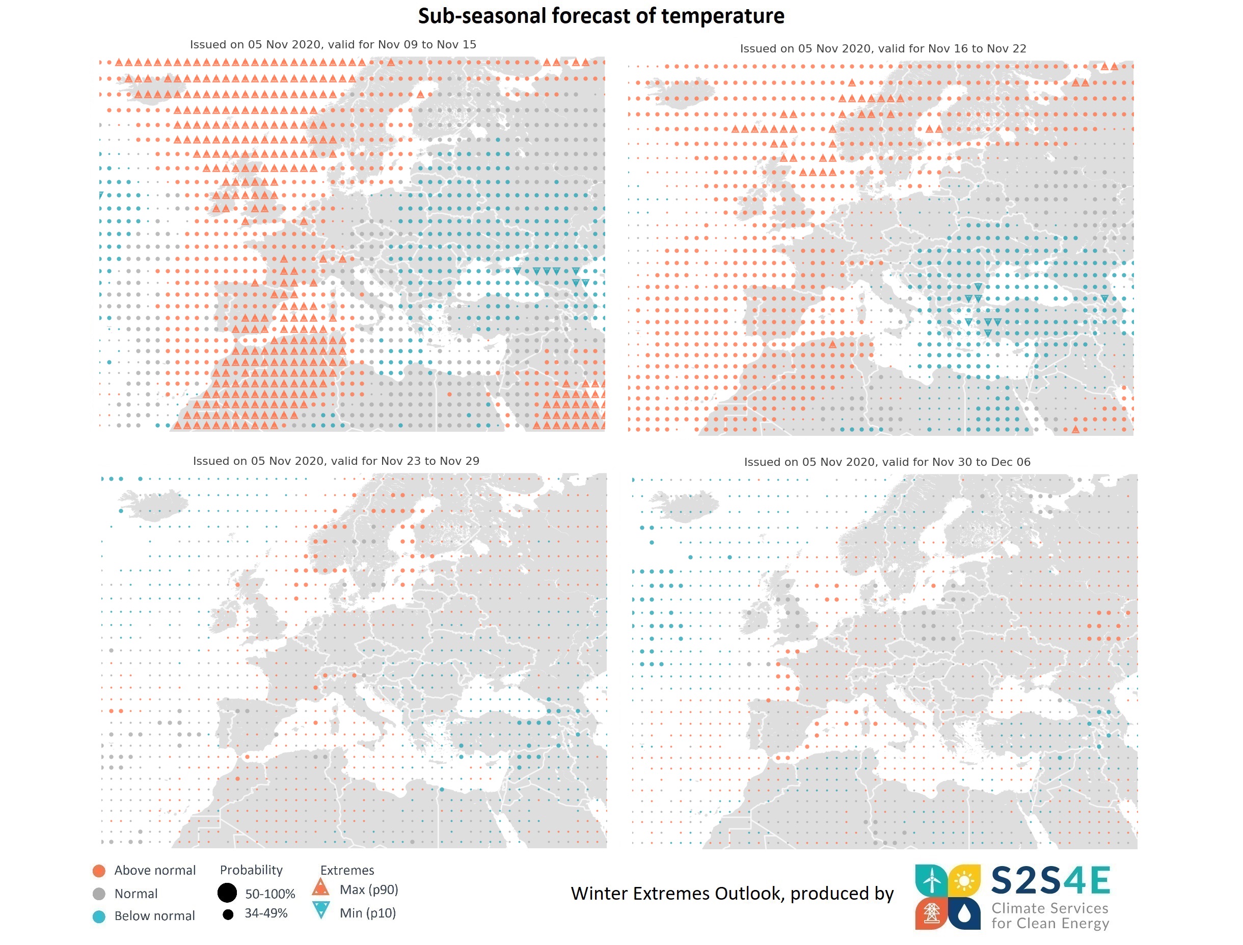
Sub-seasonal forecasts issued on the 5th of November predict hotter than normal temperatures for the season with risk of extremes during the week 9-15 November in the UK, Iceland, North Sea and Norwegian Sea, as well as in parts of Norway, southern France, northern Italy and Spain. By contrast, colder than normal temperatures are expected in eastern Europe. Forecasts for the week 16-22 November predict that high temperatures for the season will persist in western and northern Europe, with a risk of high extremes in parts of Norway. Also, below normal temperatures will persist in eastern Europe, with a risk of low extremes in Turkey, Bulgaria and the Aegean Sea. Forecasts for 3 and 4 weeks ahead show no clear signals of temperature extremes.
Outlook - 30 October 2020
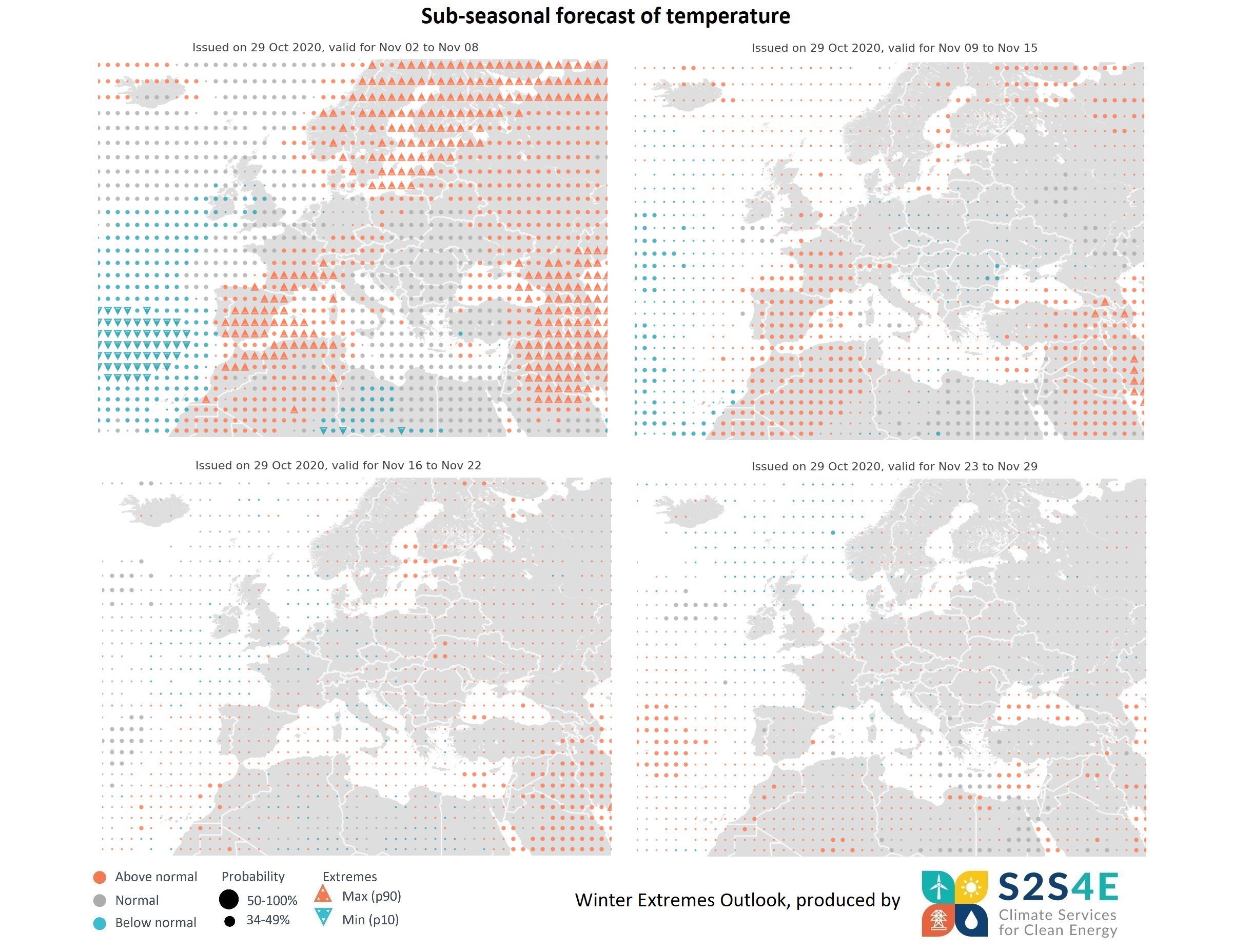
Sub-seasonal forecasts issued on the 29th of October show that high temperature extremes are expected throughout southwestern and northeastern Europe in the first week of November (2-8 Nov). Exceptionally high temperatures will particularly affect Scandinavia, Baltic Sea countries, southern France, Switzerland, northwestern Italy and the Iberian Peninsula. However, normal temperatures for the season are expected in eastern Europe and the Balkans. Forecasts for 2 weeks ahead (9-15 November) predict above normal temperatures in France, Spain and Portugal, although a risk of extremes in not clear. Forecasts for 3 and 4 weeks ahead show no clear signals of temperature extremes.
Summer Extremes
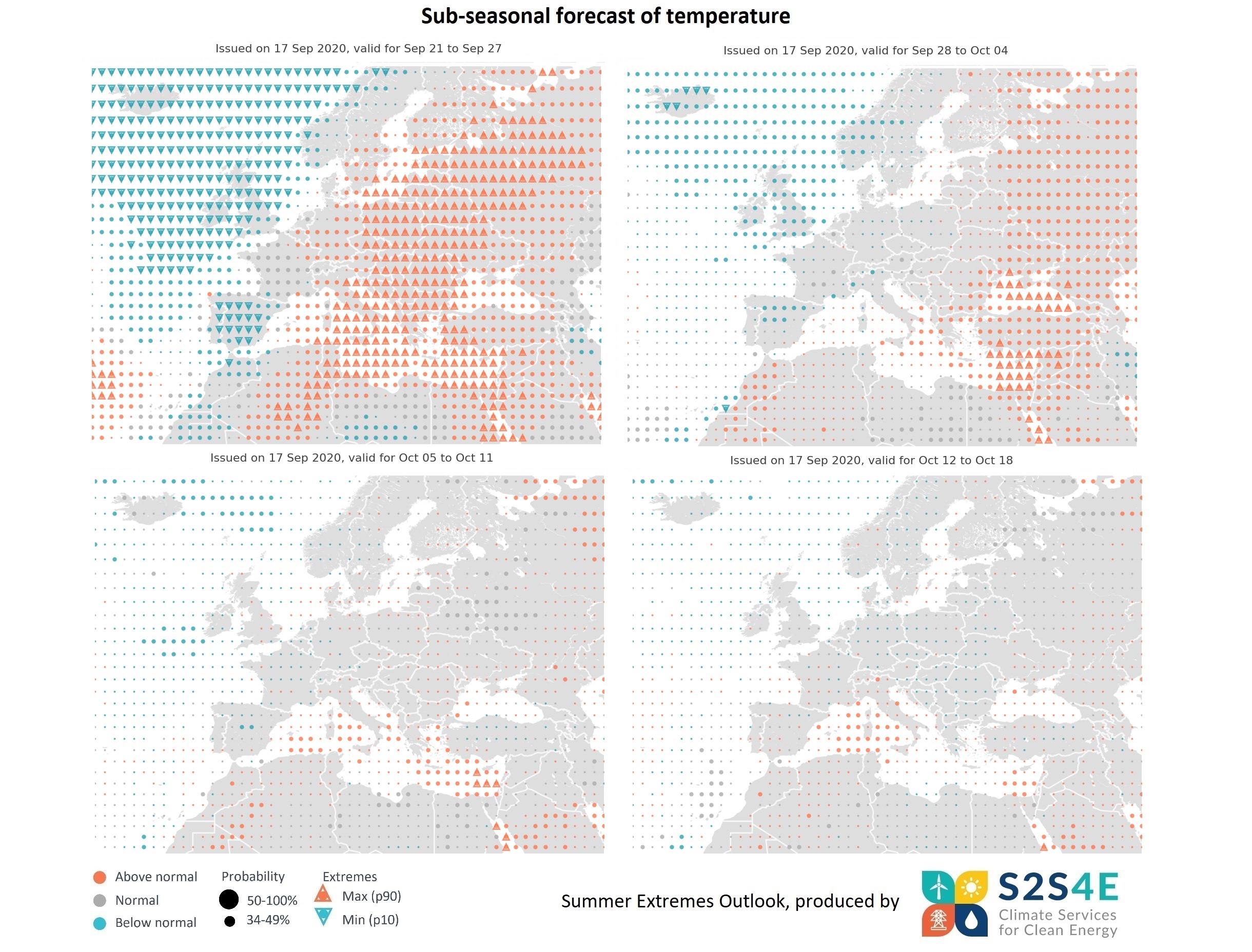
Sub-seasonal forecasts issued on the 17th of September predict that unusually high temperatures for the season are expected throughout most of central and eastern Europe, and the Mediterranean Sea during the week of 21-27 September, with a risk of high extremes. By contrast, below normal temperature are likely to be seen in the Iberian Peninsula, the UK and the western coast of Norway. These temperature patterns are likely to persist in the week 28 September to 4 October, however high extremes are only expected around the Black Sea and eastern Mediterranean, particularly in Cyprus and southern Turkey. Forecasts for 3 and 4 weeks ahead do not show any strong signals of extremes, although temperatures above normal might persist in eastern Mediterranean.
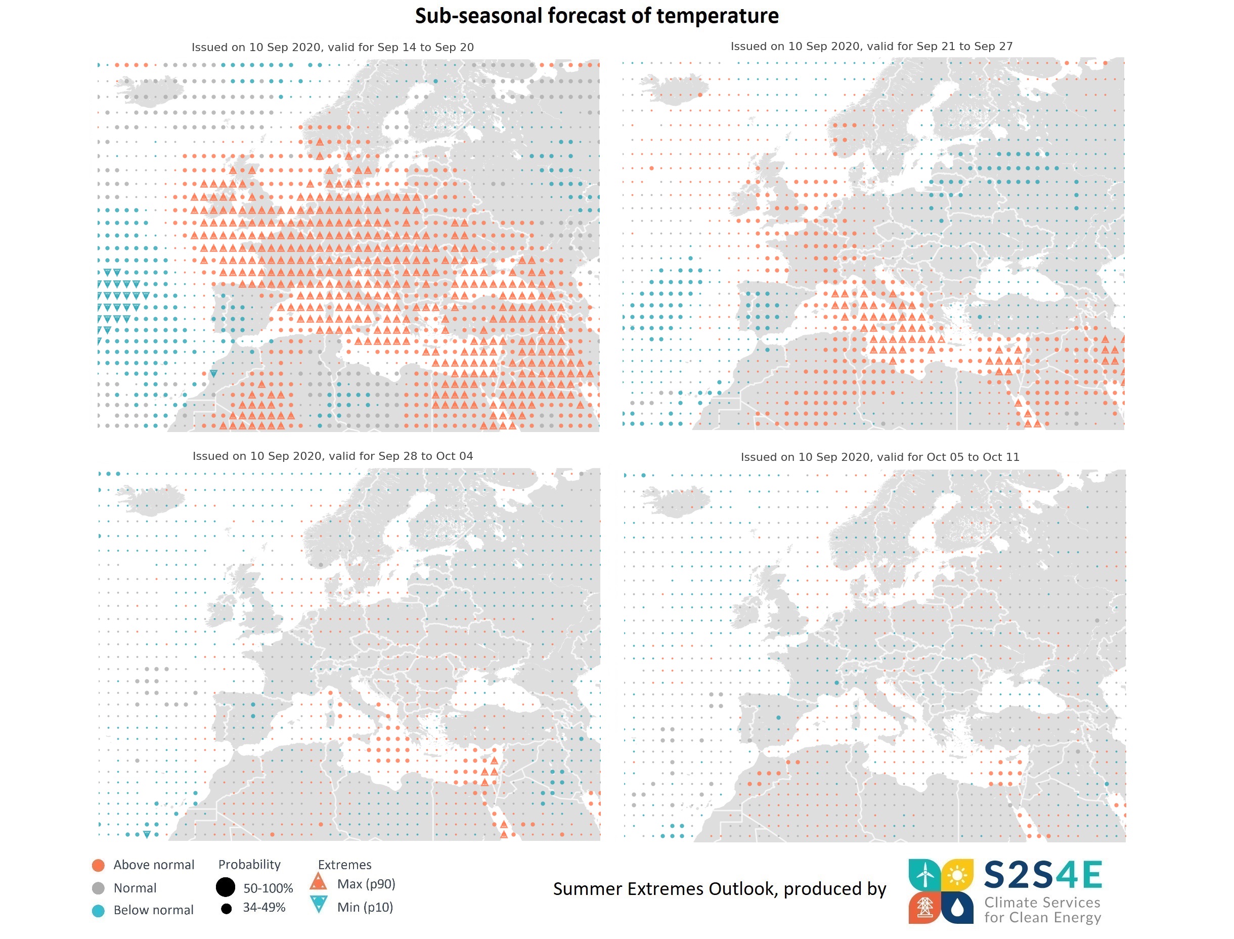
Sub-seasonal forecasts issued on the 10th of September predict exceptionally high temperatures with a risk of extremes throughout Europe, except for Portugal and western Spain, for the week of 14-20 September. High temperatures are likely to persist the following week (21-27 September) in central and eastern Mediterranean, particularly in Italy, parts of Greece, and Cyprus. By contrast, the Iberian Peninsula might see below normal temperatures until the end of September. Forecasts for 3 and 4 weeks ahead show no strong signals of extremes, although temperatures above the normal conditions for the season might persist in parts of the Mediterranean.
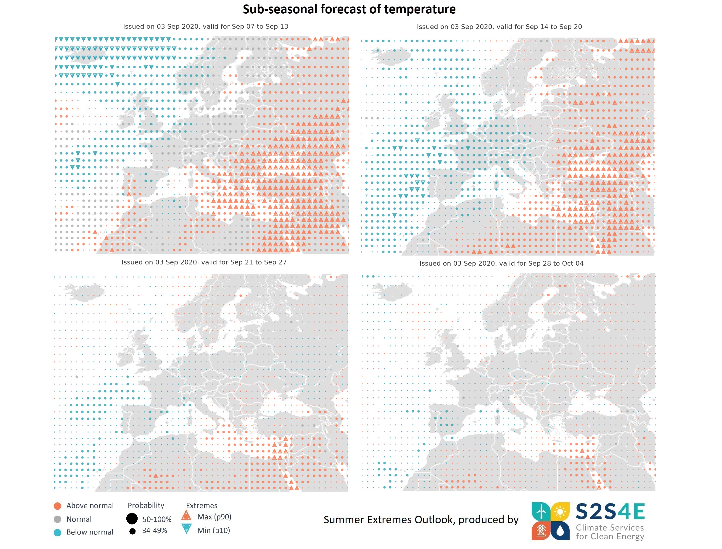
Sub-seasonal forecasts issued on the 3rd of September for 1 week ahead indicate that exceptionally high temperatures are likely to affect the greatest part of eastern Europe, eastern Mediterranean, the Balkan Peninsula, and the Black Sea. Lower than usual temperatures for the season are likely to occur in Iceland and the North Sea region.
High temperatures with a risk of extremes are expected to persist in eastern Europe the following week, from 13 to 20 September. By contrast, most regions of central and western Europe are predicted to experience below normal temperatures this week.
Forecasts for 3 and 4 weeks ahead show no strong signals of extremes, but temperatures are likely to continue to be above normal in eastern Mediterranean and the Red Sea.
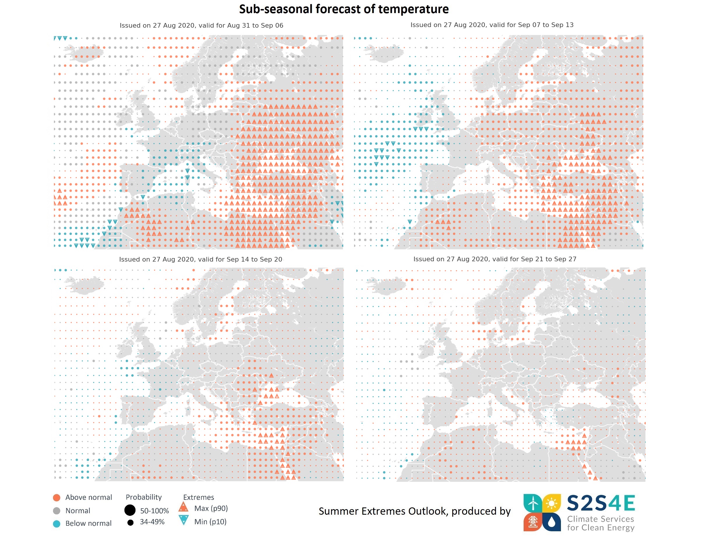
Forecasts issued on the 27th of August predict a risk of high temperature extremes during the first week of September in the greatest part of eastern Europe, eastern Mediterranean, the Balkan Peninsula, and the Black Sea. During this week, warmer than usual temperatures are expected in the Baltic Sea and the Atlantic, off the west coast of the Iberian Peninsula. Lower than usual temperatures for the season are likely to occur in western Mediterranean and more specifically in Italy, the south of France, and the west coast of Spain.
From the 7th to the 14th of September, the risk of high temperature extremes is likely to persist in eastern Mediterranean countries, the Red Sea, and the Black Sea. Warmer than usual temperatures are expected in the central and eastern Europe, the Baltic Sea and the north of Africa, while below normal temperatures are likely to occur in Ireland and the east coast of the UK.
Forecasts for the week 14th – 20th of September suggest that above normal temperatures are likely to persist in the eastern Mediterranean region, the Balkan Peninsula, and the Black Sea, with a risk of localised extremes.
Forecasts for the week 21st – 27th of September show some signals of heat extremes along the coast of Lebanon, Israel and Egypt, as well as in the Red Sea.
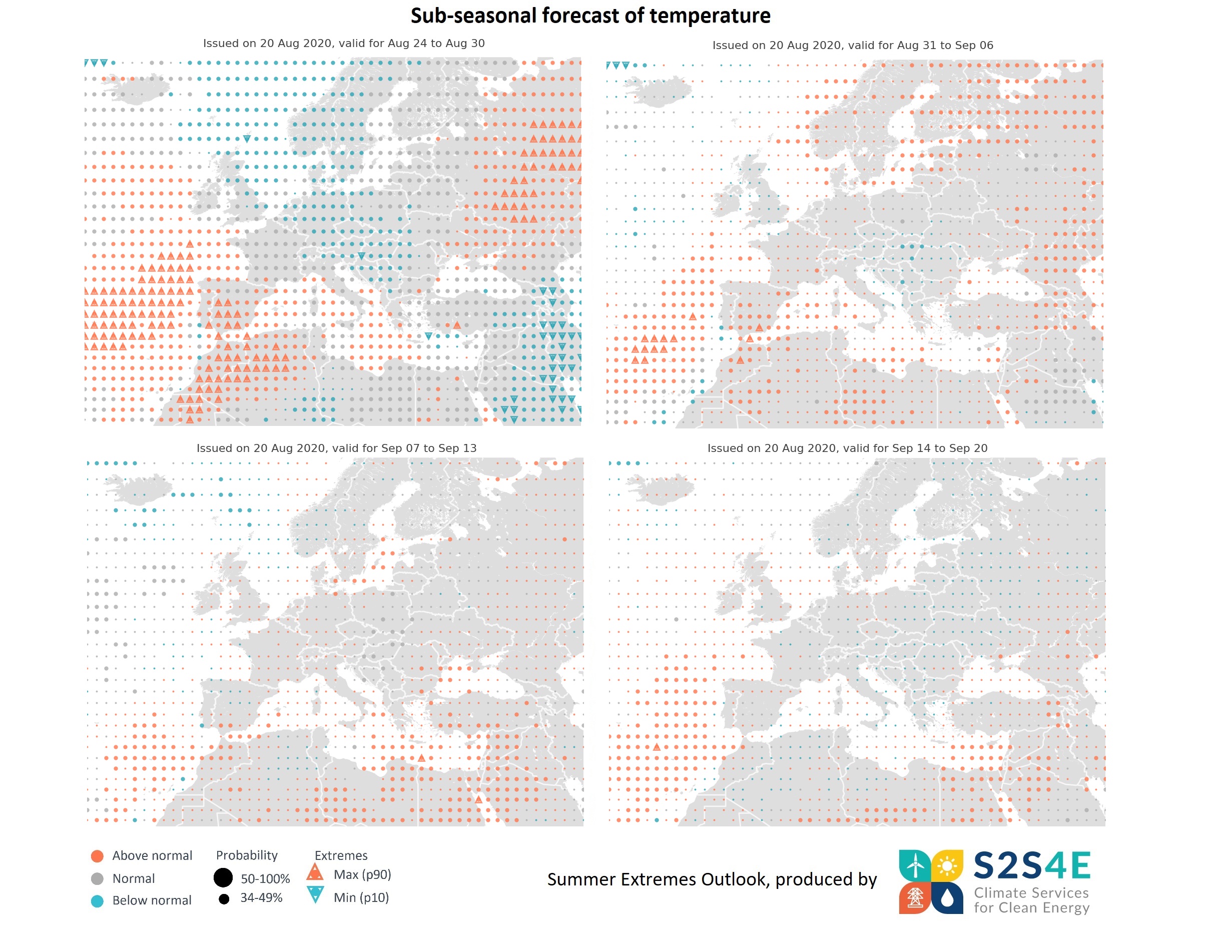
Forecasts issued on the 20th of August predict a risk of high temperature extremes during the last week of August (24th-30th) in the south of the Iberian Peninsula, North Africa and in the Atlantic off the west coast of the Iberian Peninsula. During this week also the Mediterranean basin will experience warmer than usual temperatures.
From the 31st August to the 6th September warmer than usual temperatures are expected in the Iberian Peninsula and Scandinavian countries, with some localised risk of high temperature extremes in the south of Spain and Northern Africa.
For the week 7th-13th September higher than usual temperatures are expected towards the eastern Mediterranean Sea, which will persist the following week 14th-20th September.
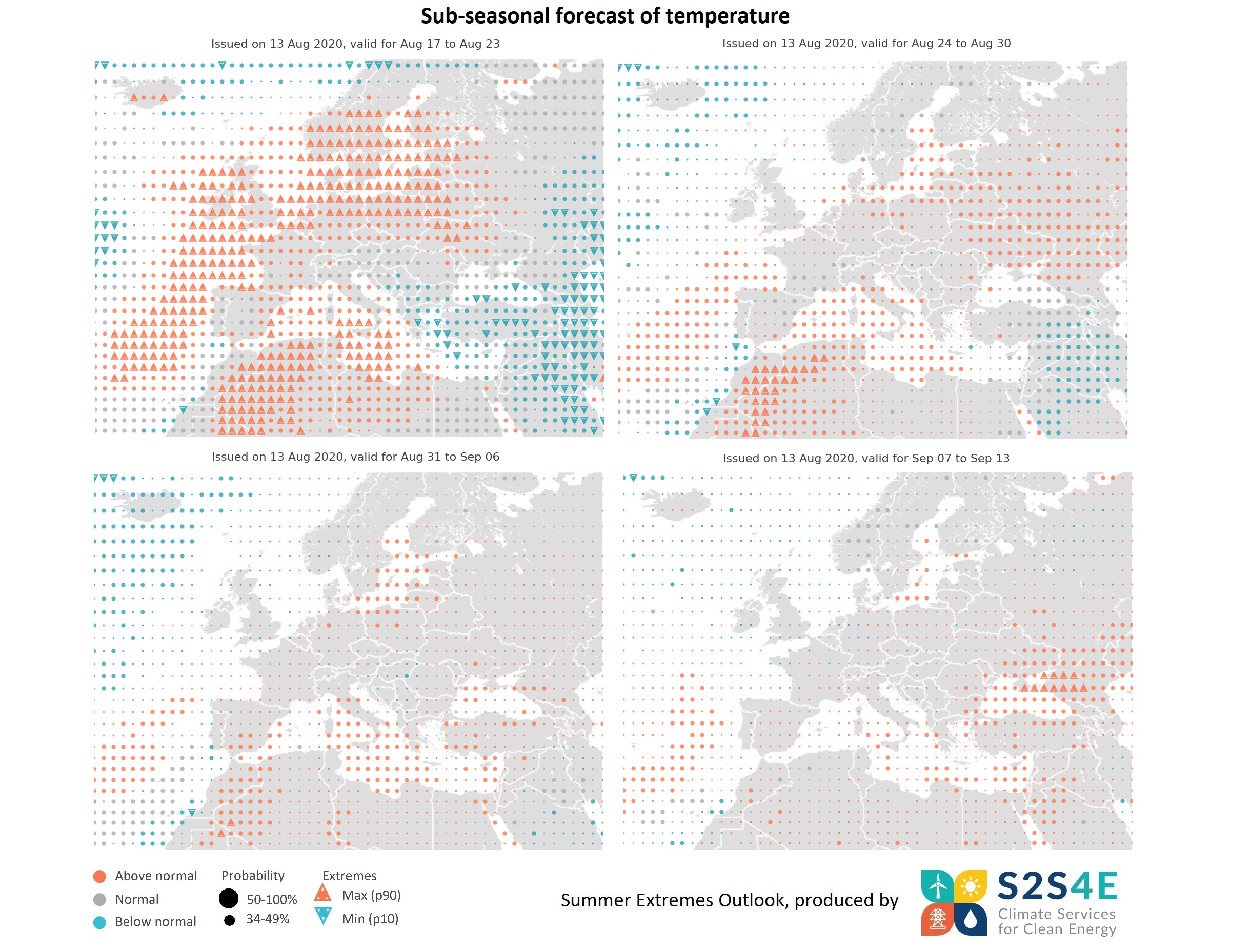
Forecasts for 1-4 weeks ahead, issued on the 13th of August, predict a risk of temperature extremes in the greatest part of north-eastern Europe, the Mediterranean Basin, North Africa and the Atlantic Ocean, between the 17th and the 23rd of August. The risk of unusually high temperatures will mainly affect southern Scandinavia, the Baltic countries, western UK and Ireland, the north of Poland and Germany, Belgium, and the Netherlands. In the Mediterranean Basin, exceptionally high temperatures are expected off the south coast of Italy, while unusually low temperatures for the season will be seen in the Aegean Sea.
Higher than usual temperatures are expected in eastern Europe, the Baltic Sea, western Mediterranean and the Atlantic during the last week of August, while the risk of heat extremes persists in the northeast of Africa. Forecasts for the first week of September suggest that above normal temperatures are likely to persist in the western Mediterranean, the Baltic Sea and the northeast of Africa, while no signals of extremes are seen. Forecasts for the week 7th – 13th of September suggest higher than usual temperatures in the Black Sea, with a risk of extremes.
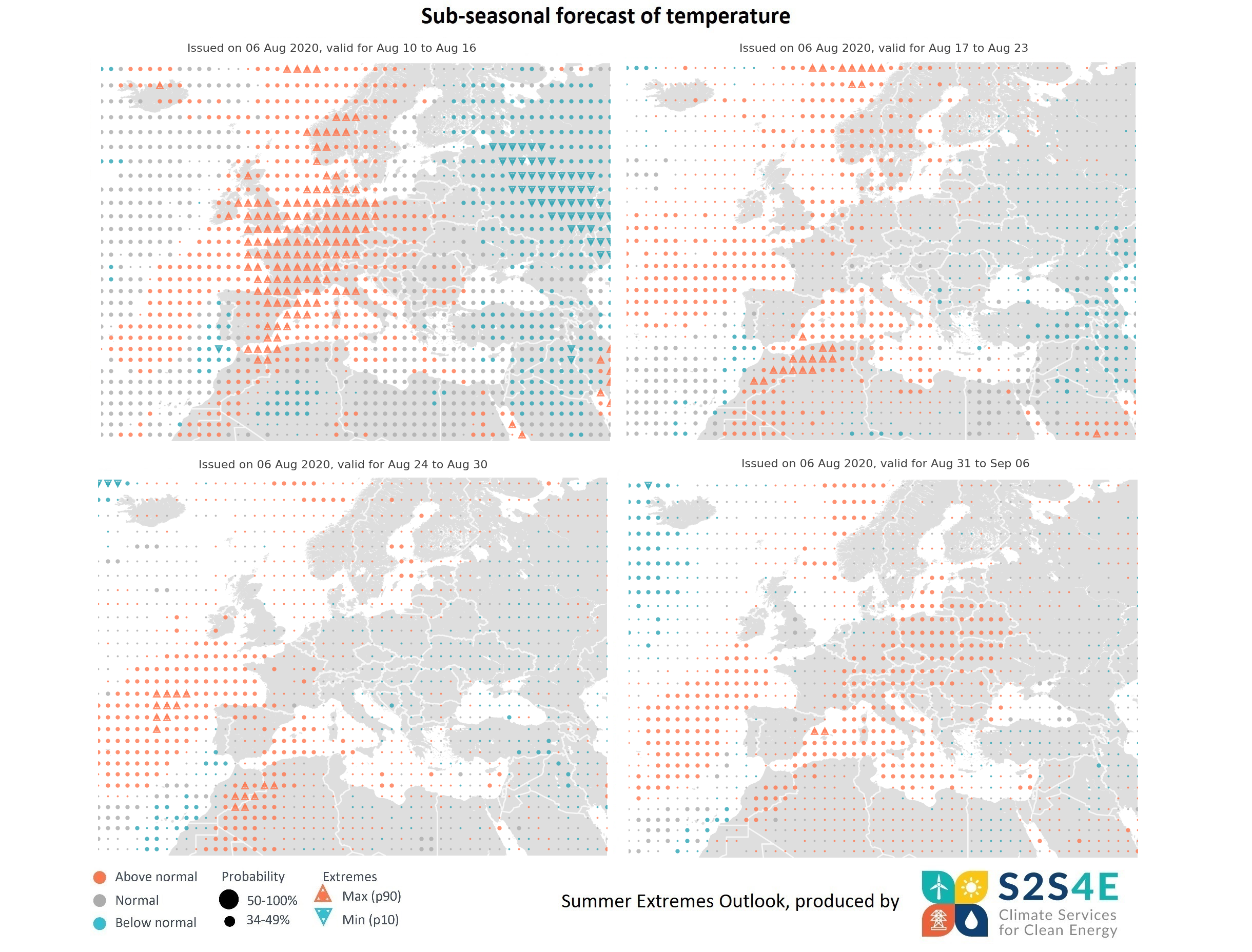
Sub-seasonal forecasts issued on the 6th of August for 1 week ahead indicate that exceptionally high temperatures are likely to affect central and western Europe, particularly France, Germany, the UK, and parts of Italy, Spain and Norway, with a risk of extremes. For the week of 17 to 23 August, the forecast shows no clear signal of temperature extremes, although higher than normal temperatures are expected in the western Mediterranean and parts of Scandinavia. No clear signal is produced by the sub-seasonal forecasts for the week of 24 to 30 August. For the first week of September, forecasts predict above normal temperatures in central and eastern Europe, and Italy.
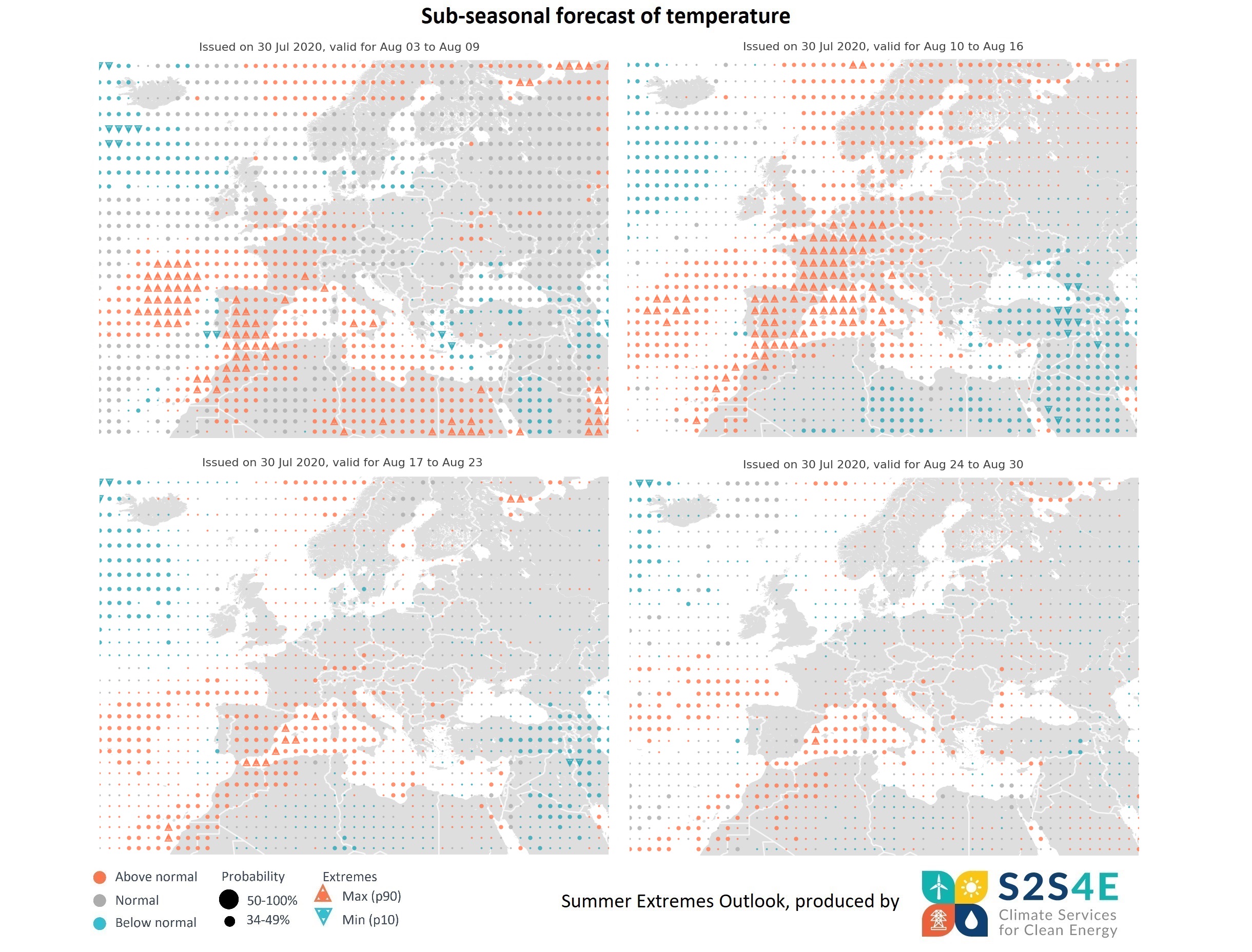
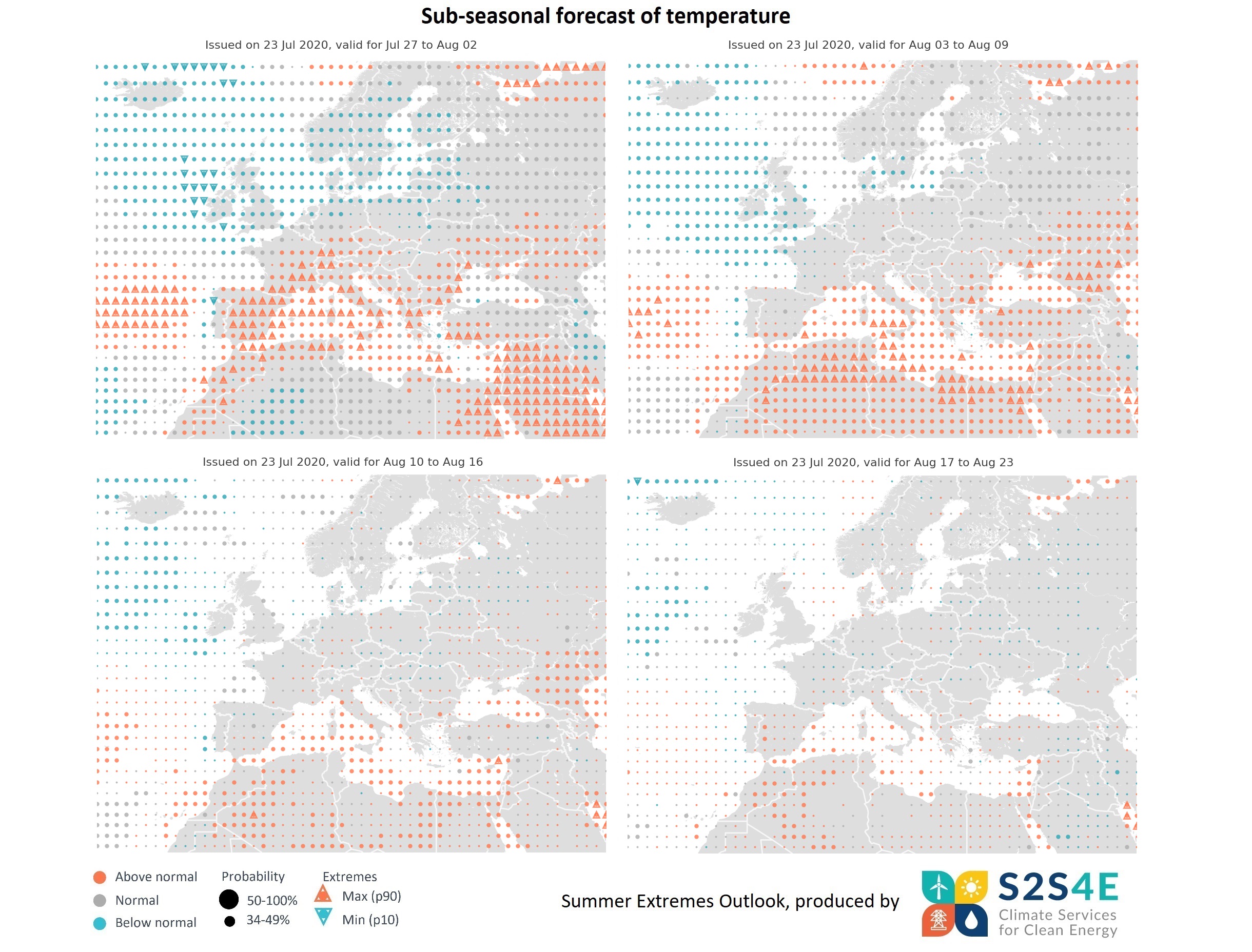
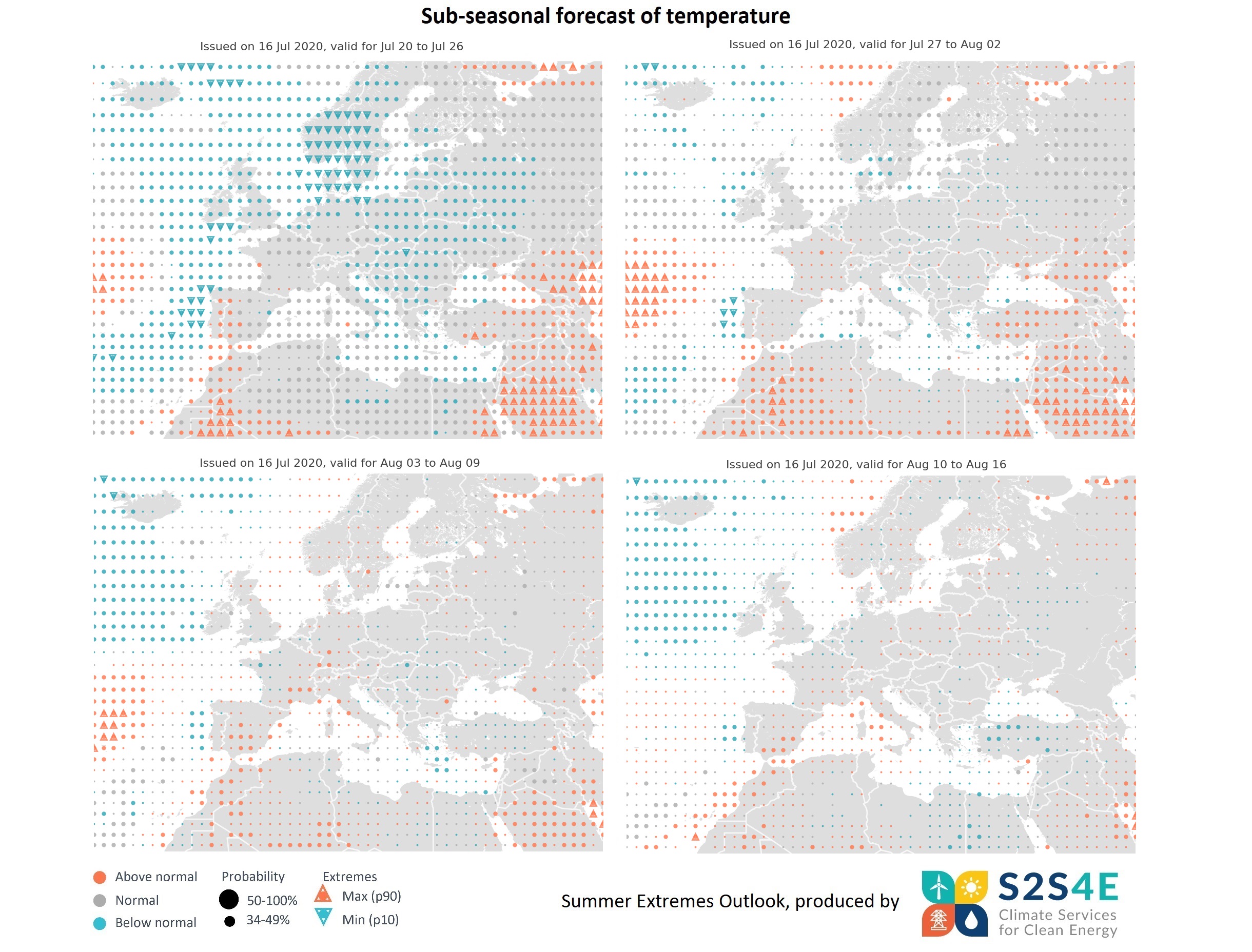
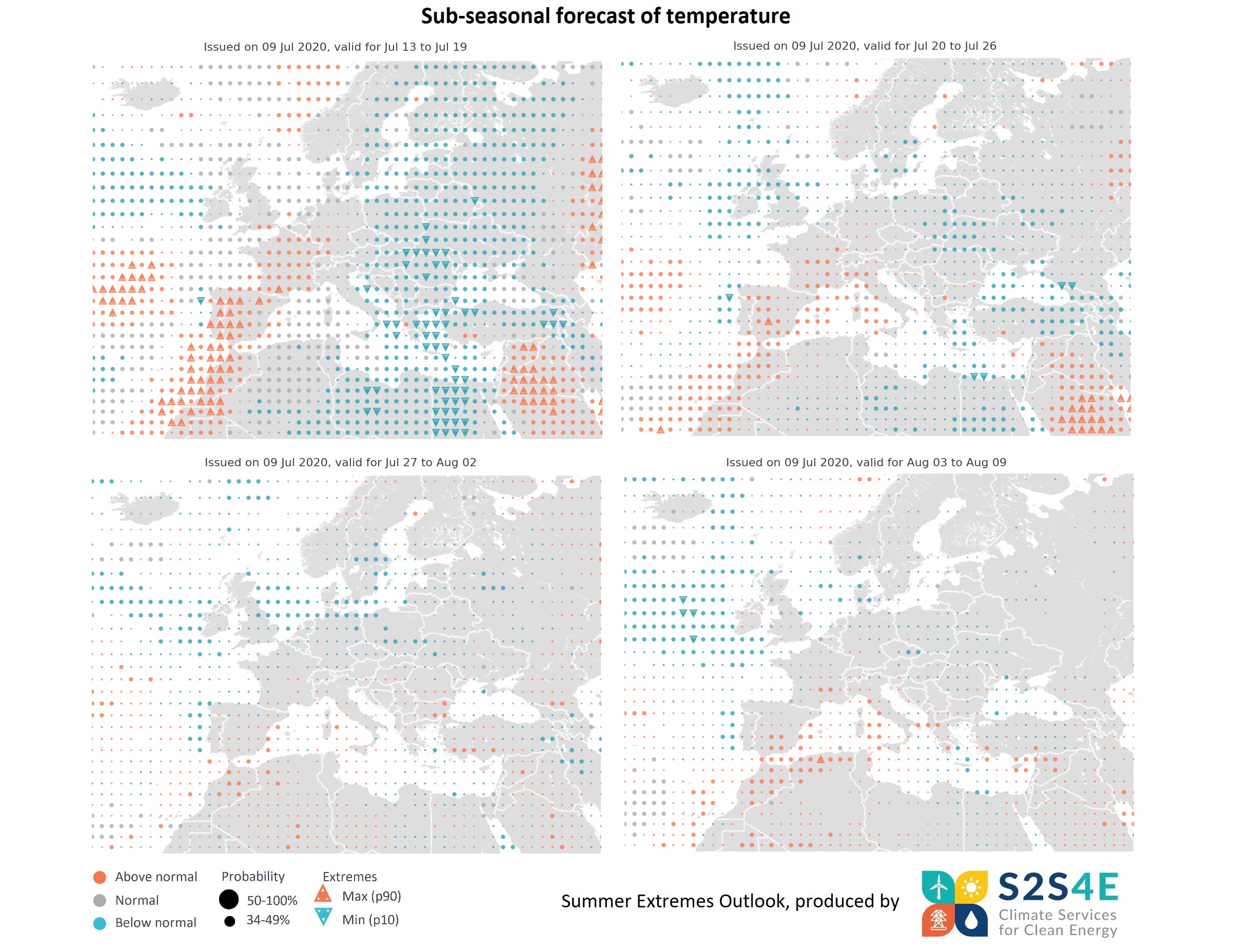
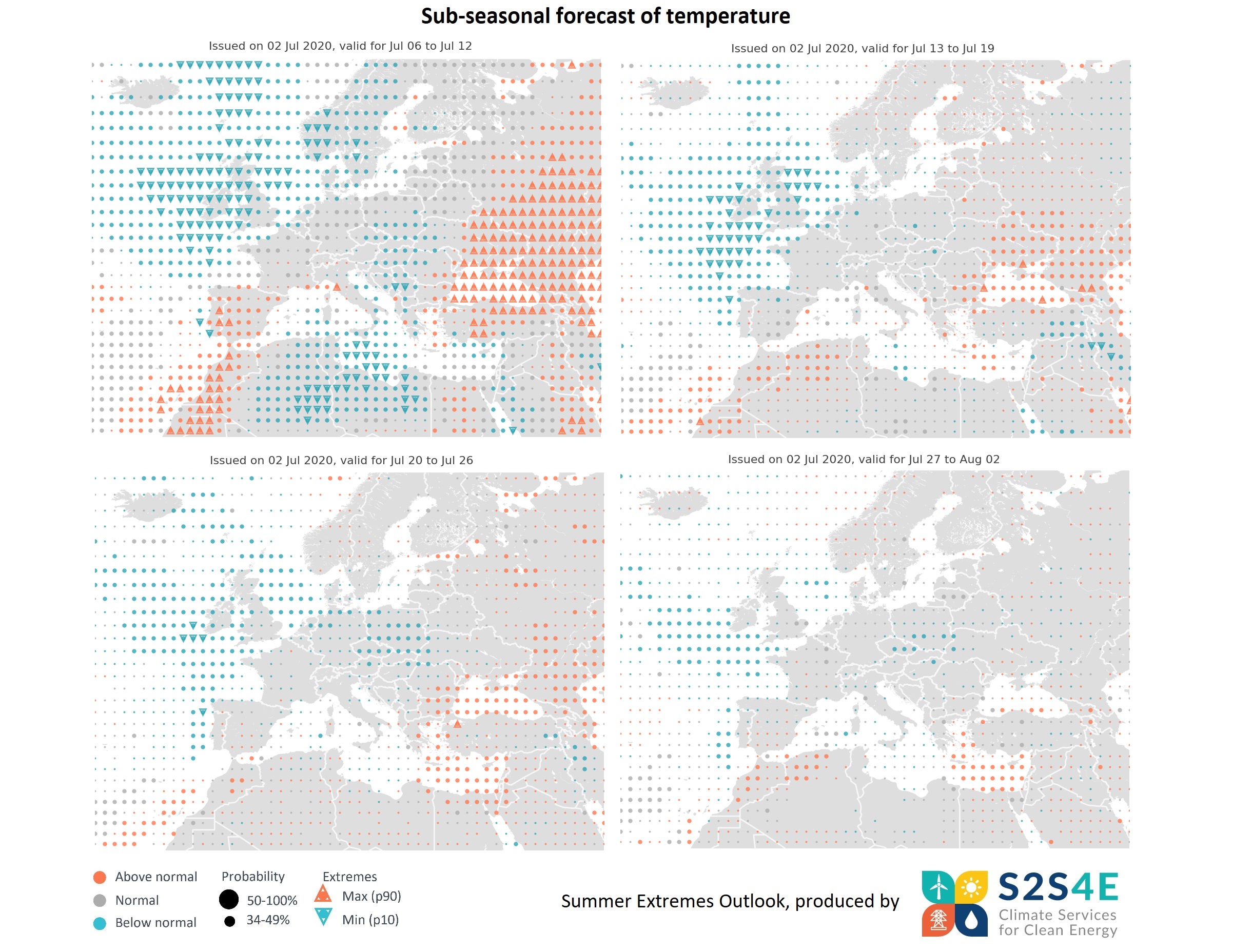
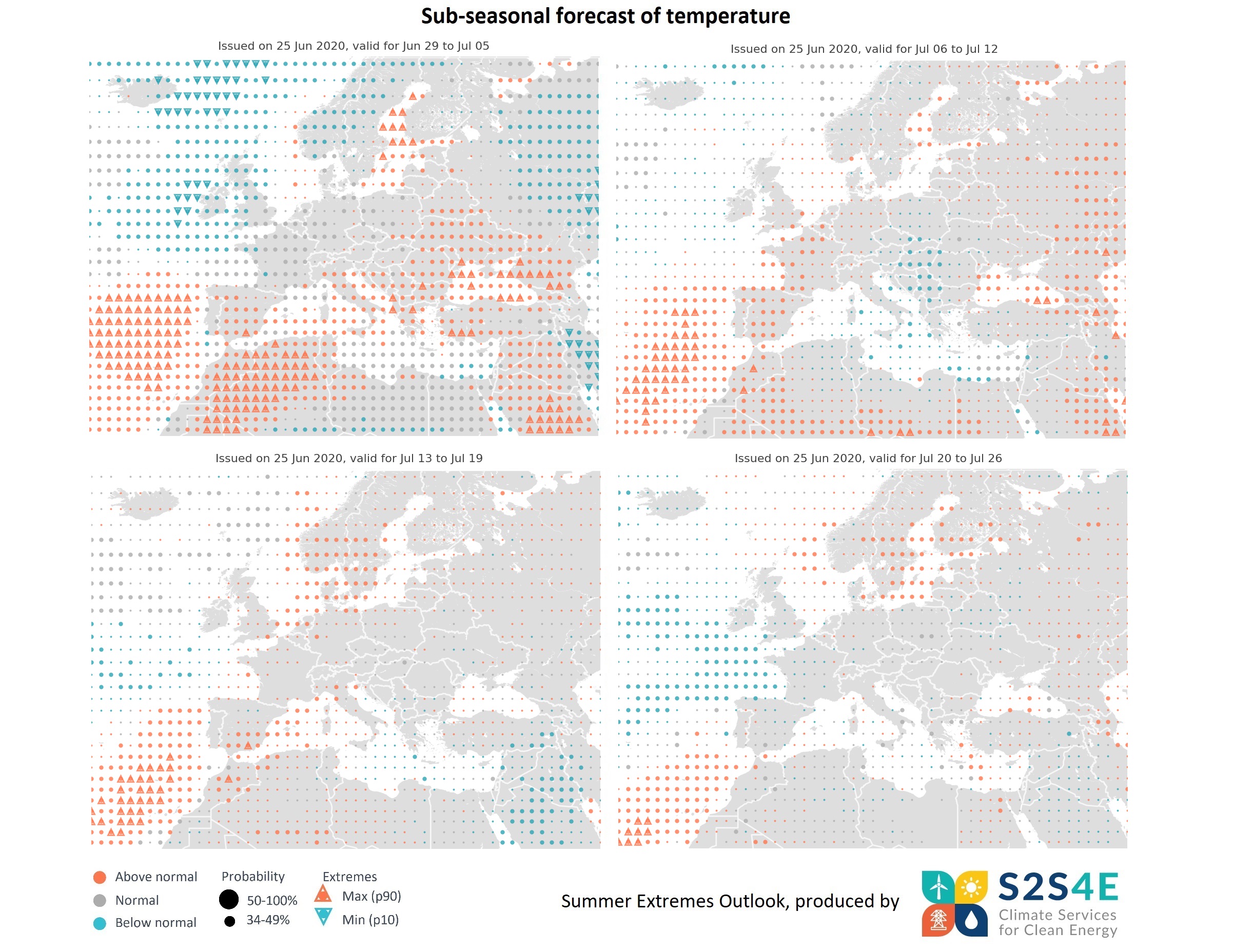
Higher than usual temperatures are expected in the Iberian Peninsula and west France between the 6th and the 12nd of July, while the risk of heat extremes persists in the north of Africa and the Black Sea. During the week 13th -19th of July, higher than usual temperatures are likely to affect the Mediterranean coast of Spain, the Canary Islands and southern Sweden and Norway. Forecasts for the week 20th -26th of July indicate that higher than usual temperatures are likely to persist in southern Scandinavia.
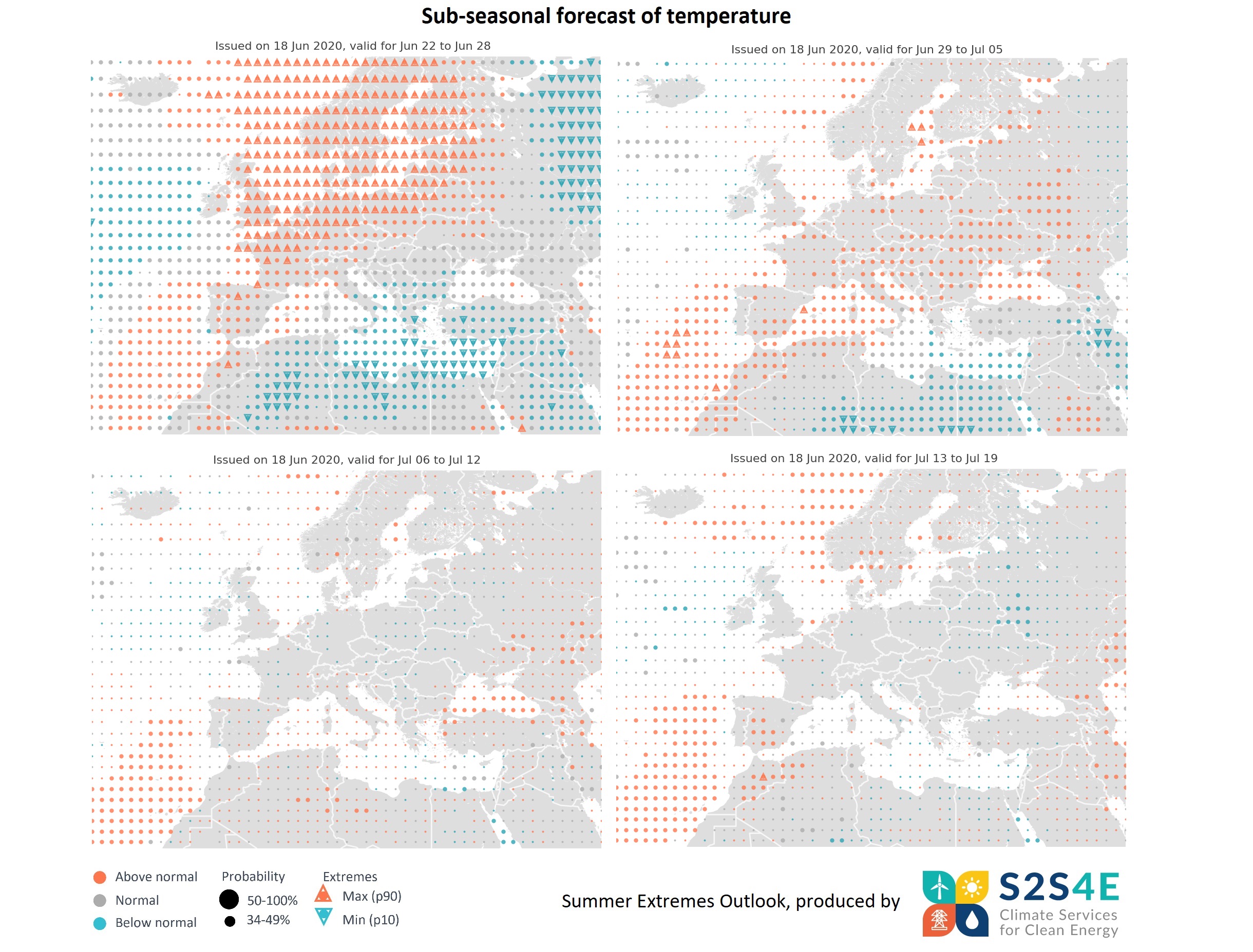
Forecasts for 1-4 weeks ahead, issued on the 18th of June, show that unusually high temperatures are expected across northern and central Europe between the 22 and 28 June. These temperature extremes will mainly affect the northern parts of France, Germany and Poland, and the UK, Scandinavia and Baltic countries. Temperatures above the normal conditions for the time of year are likely to be seen in parts of central, eastern and southwestern Europe in the week of 29 June to 5 July, although there is no clear signal of extremes. Forecasts for 3 and 4 weeks ahead do not show any clear signals of summer extremes, but indicate that high temperatures are likely to persist in the Canary Islands.
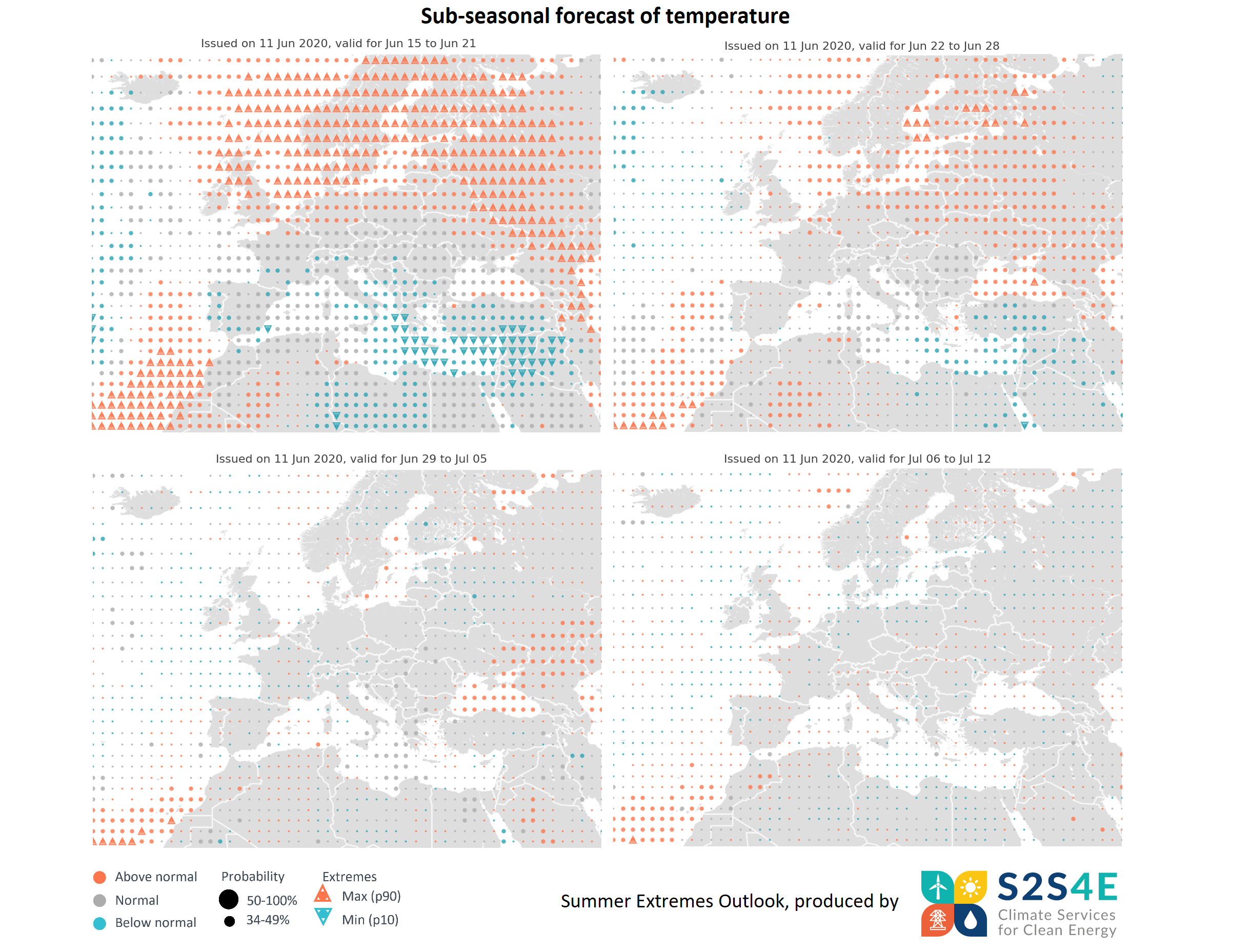
Forecasts for 1-4 weeks ahead, issued on the 11th of June, show that exceptionally high temperatures are expected in northern and eastern Europe for the week of 15-21 June. These temperature extremes will mainly affect Scandinavia, Baltic countries, the north of the UK, eastern regions of Europe and the Canary islands. Temperatures above the normal conditions for the time of year are likely to persist in parts of Scandinavia and the Baltics in the week of 22-28 June. Forecasts for 3 and 4 weeks ahead do not show any clear signals of summer extremes.
